I tend to camp in tucked away spots in forests and such so giving my location to others can be an issue.
It occured to me that if an emergency occured (heart attack, tree falling on the caravan etc) then it's quite likely I'll be in shock at that point too and I recall the couple of times in my life when I have experienced shock it was mentally very debilitating ie. I could hardly remember my name or address so this combined with my remote locations decided me to record all the necessary details to a file on my phone such that I just need to read them off to the emergency operator, this will also simplify and quicken providing my location.
Let's say, I'm camped at the Katie Peter's campsite in Gippsland, Victoria, I'd record it as:
Katie Peters Campground, 5km east of Eskdale off Mitta North Road, near the toilet block, -36.45608S, 147.31368E
Now all I have to do is read that one line and the emergency operator, with her mapping software, can very quickly locate me to an accuracy of about 5m. Depending upon your situation it may also, or instead of the phone, be useful to record this information on a piece of paper located somewhere easy to find.
Most GPS' readily provide Lat/Long data but if not this free app. for Android phones will do it (I'm sure there is an app. for Apple too):
I have a couple of apps on my phone on the main screen.
Just open it and push a button. Some work all over the worl
https://photos.app.goo.gl/sSCwivgV1RKXvAYT7
I have organised a 10-12 week tagalong with 10 other Trayon camper owners across to Perth and back to Mornington, Vic. A few will do the whole trip, but most will join us at various stages - primarily for the Simpson leg. Over the 12,000k trip, we pass through 5 deserts, 5 states' outback areas and NT via the Ann Beadell and Simpson. Trayonners prefer to free camp at every opportunity because the Trayons are built for self sufficiency.
Preparing ourselves for whatever may happen involves heavy research and an information sheet to keep everyone on the same page. It is all made easier by the shared collective experiences and equipment, so after a little dune practice for relative newbies, the convoys should be OK.
I have a detailed spreadsheet of the GPS locations for each day, with mileage and route maps which I will send to each local authority (Parks, police, etc.) so they can trace us if we fail to report in on time. There will be a number of PLB's and sat phones as standbys, too.
When I have responsibility for so many other travellers, I can't afford to leave much to chance!
If I'm travelling on my own, ditto!
__________________
2008 Landcruiser single cab chassis, 2.7m tray. (Sad to part with the 2005 Isuzu, tho)
No one is ever going to come out on top in this discussion while multiple choices are available for describing a location. There are just too many "Standards" or "Conventions" unless you use an Iphone, in which case it appears nothing else matters...
No one is ever going to come out on top in this discussion while multiple choices are available for describing a location. There are just too many "Standards" or "Conventions" unless you use an Iphone, in which case it appears nothing else matters...
it is good that this subject comes up every so often, even if only a few people take notice, and realize how difficult it could be to pinpoint your location if you happen to be one of the first on the scene of some emergency or other situation that requires you to explain your location.
One quick way of determining your position coordinates on a Google Pixel smartphone is to take a photo and look at the details accompanying the photo. The coordinates are shown at the bottom of the screenshot.
-- Edited by StewG on Monday 27th of February 2023 06:12:43 PM
This thread has been helpful because it jogged me to do something about it.
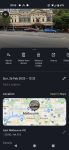
I downloaded the Emergency Plus app. It's recommended by our local emergency services. You get a big button to dial 000, and buttons for Police and SES as well. It displays your GPS information including street address if there is one. The app also had a link to the What3Words app listed above. I downloaded that, created an account and saved the location.
If we do need emergency support, it is bound to be a really stressful time. I can easily believe being unable to remember what app to run or how to use it, at the same time as having impaired vision to read the screen, and possibly confused as well. In those circumstances, repeating 3 words is a lot easier and less prone to mistakes than GPS coordinates, that may be transposed in error.
So, if going to a remote location, my plan is to get the 3 words for that location and save them in the app. Then write them in large print on a piece of paper with very simple but brief memory joggers on what app to run and what to do. Then this piece of paper gets tucked into the phone wallet. Another benefit here is if someone else is able to go for help, those 3 words will be all that is necessary for location. There may be no phone signal to phone anyway.
A quick warning. I installed these while inside home. The GPS did a very poor job of pinpointing my location, jumping up to a few kilometres away. But once outside it locked my position within seconds.
In those circumstances, repeating 3 words is a lot easier and less prone to mistakes than GPS coordinates, that may be transposed in error.
I don't agree.
What3Words was developed as a utility for delivery drivers and such to find, say, the required door in a large building, it divides the planet into 6m squares to obtain the required precision, it was never intended to be a spoken reference.
I trialled What3Words for about six months whilst regularly moving around Victoria and southern NSW and my conclusion was that it's fine for delivery drivers but far less than optimal for emergency situations.
The major problem with it is the diverse content of its word database; ie. it contains many words which are rarely used and may not be known to many people, here is a sample:
As best I can tell it keeps the short, simple words for city locations and the above type for country locations.
Imagine: a tree has fallen on your caravan, you are trapped and in pain with a broken leg, the rain is soaking you, the wind is howling into your phone, the phone line is flakey and you are trying to persuade the emergency operator to understand "publish logos subliminal" - good luck with that.
However everyone knows and is familiar with the digits 0 to 9 so conveying 143.805 and 34.274 is a far more straightforward task and will locate you to about 100m, if you wish to provide a fourth digit the resolution improves to 10m.
The app. I referenced in my first post will provide a decimal lat/long and is simple to use and understand. Ensure you use *decimal degrees*, degrees, minutes and seconds are too prone to confusion.
Most importantly: DO NOT WAIT FOR AN EMERGENCY BEFORE OBTAINING YOUR GPS LOCATION because your GPS may have problems obtaining lock on the satellites, get a location fix soon after you arrive when all is rosey with your world.
Finally: if you insist on using What3Words wander around the vicinity of your campsite until the app. provides three words you think you have a fighting chance of getting the operator to understand.
__________________
"I beseech you in the bowels of Christ think it possible you may be mistaken"
Oliver Cromwell, 3rd August 1650 - in a letter to the General Assembly of the Kirk of Scotland
As well as a PLB we have a satphone. It is now a satsleeve Hotspot - uses our mobile phone - recent change. We think in an emergency, for some of the reasons Mike lists regarding emergency situations, that it is safer than our old 'standalone satphone'. It provides us with a satphone which is 'familiar' - far better than something we had almost never used, & always had to try to work out how to use it each time we did.
We too have the Emergency Plus app on the iphone & ipad. One click to open it & it instantly tells our latitude/longtitude, What3words & a location map which can be zoomed whilst the location info remains clear. (I think we need to have the What3Words app, in order for the 3 words to appear in the Emergency+ app, but not certain).
If we call 000 this info remains on the screen.
It works pretty well, I am currently inside a house, surrounded at close quarters on all four sides by dense rainforest & it has located me instantly. On it's own it is however of no use at all as we have no mobile phone signal with which to call anyone. (Here we only have wifi calling via satellite - not fantastic when it works, & the internet drops out whenever it rains).
I do appreciate that there may be times when the gps may not locate us instantly, or at all, in conditions of heavy cloud/storm activity or being under heavy tree cover or deep in valleys where we couldn't 'see' the satellite.
In those conditions we wouldn't be able to tell anyone our position anyway, because the sat phone also wouldn't work.
If the satphone works, it can also tell the location & we have tested it here.
If in an area or conditions where getting a GPS location may be difficult or not possible AND a mobile phone signal is available Then the advice to note down location is sensible if staying there for a bit, but of little use if you don't have a mobile signal. At our current location due to having the possibility of wifi calling intermittently we do now have a screenshot (entitled EMERGENCY LOCATION) from the emergency Plus app on our computer desktop & ipad showing our location (as a result of this thread).
However we mostly don't have a mobile phone signal in many places we travel & are thus reliant upon getting a satphone signal to communicate other than with the PLB in an emergency. (In our view the PLB is the emergency 'first line').
My wife & I long ago had the conversation about 'remote area risk', whilst we were at a location well out of range of emergency choppers, & with the nearest landing spot for a fixed wing aircraft being 4 hours of rough 4wd'ing away, & confirmed to each other what we had once talked about before going to places like that. Essentially accepting there is risk in most things we do, but as we love doing them we have to accept the risk (mitigated by preparation) or not enjoy what we do because we would worry all the time. We have no death wish, but bottom line is that we would rather perish doing something we love than to perish wishing we had done something we loved.
-- Edited by Cuppa on Tuesday 28th of February 2023 11:13:55 AM