The next 24 hours should give a better indication on where it will cross. The models at the moment are showing just north of Townsville with unknown wind capacity. If it passes above Townsville then we will receive a lot of rain and strong winds. Depending on the size anywhere from Mackay to the north will get wind and rain due to the shape of the coast.
I would not be proceeding too far north of Mackay until after it has crossed and roads reopened.
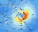
The diagram is a model from GFS at 4pm on Sunday with winds ranging from 25kts north of Mackay to 53 kts at Townsville roughly 45 to 95 kph. It will probably be a bit rough for caravans.
Make sure you check for updates before travelling. Keep safe