TROPICAL CYCLONE ADVICE NUMBER 6 Issued at 5:27 pm EST on Saturday 25 March 2017
Tropical Cyclone Debbie is expected to cross the coast between Townsville and Proserpine on Tuesday morning, most likely as a CATEGORY 4 tropical cyclone, with wind gusts up to 260 kilometres per hour near the centre.
K.J.
__________________
From Coast to Coast, We'll see it all.......One Day
Do they say how far inland those high winds and heavy rain are likely to reach kiwijims?
At this stage there is a lot of speculation on that score Happywanderer,
All I've seen so far is this comment...........
Tuesday. Major river flooding may also develop over a broad area next week and a Flood Watch is current for coastal catchments between Cairns and Gladstone, extending inland to the eastern Gulf River catchments.
Nothing stated so far regarding wind .inland.
__________________
From Coast to Coast, We'll see it all.......One Day
The cyclone that hit Innisfail did heavy damage on the Atherton Tableland . So you can't be sure , I would head north of the danger zone not west or south .
The cyclone that hit Innisfail did heavy damage on the Atherton Tableland . So you can't be sure , I would head north of the danger zone not west or south .
From Mackay, we don't have a big choice. We don't have the time to go direct north, With the caravan on, we cant go through Eugella NP, have to go south west to Moranbah/Clermont thence to Charters Towers.
__________________
Pay it forward - what goes around comes around
DUNMOWIN is no longer on the road and still DUNMOWIN!
Thanks for the updates. I'm at Monto at the moment. The caretaker here when I said I was heading to Sapphire, suggested I hold back for a while as the heavy rain could bring flash flooding in that an cq area.
Trying to work out where there's a camp on high ground where I would be comfortable for about a week.
He said even here in Monto has flooded with the rain from previous cyclones.
Please everyone who may be affected. This is a serious cyclone. Check BOM for previous cyclone data. Currently in Cairns just a beautiful evening. And many southern places are the same. Complacency is dangerous.
Please everyone who may be affected. This is a serious cyclone. Check BOM for previous cyclone data. Currently in Cairns just a beautiful evening. And many southern places are the same. Complacency is dangerous.
We are Cairns locals wanting to go South next week! Smart enough to delay if necessary our travels. Mother Nature is a powerful force. Stay safe fellow travellers.
Tuesday mornind is HIGH TIDE, so the storm surge could be devistating. Its 3.67m at 9am here on Magnetic isand. Add 3m of storm surge, and we have problems......Sincerely hope it doesn't come here.I,ve done all the prep, and I live high up , so its just wait and see.(and ckeck my insurance)............
You shouldn't take the warnings lightly, just remember the destruction of Yashi & Larry. Those of us in coastal areas in the south have probably only faced a east coast low and they by themselves are destructive (Newcastle region 2014) a cyclone is 4-5 times worst. Current warnings are flooding from Cairns to Gladstone, not to mention days of a high intensity low afterwards aswell as towns as far west as Charters Towers still expecting the effect of a low level cyclone.
Bom Watch Zone remaining coastal areas from Cairns to Ayr including Innisfail and Townsville, extending inland to Charters Towers and Mount Coolon
-- Edited by Kebbin on Sunday 26th of March 2017 09:51:06 AM
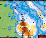
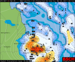
For those travelling in North Queensland and have limited data resources I have copied three projected cyclone positions, two with projected position, winds and rainfall on Tuesday.
Projected position of cyclone 4pm Monday 27th
Rain Area on Tuesday morning at 4am and 10am
Projected cyclone position and wind strengths on Tuesday morning at 4am and 10am
Details of Tropical Cyclone Debbie at 1:00 pm AEST: Intensity: Category 2, sustained winds near the centre of 110 kilometres per hour with wind gusts to 155 kilometres per hour. Location: within 30 kilometres of 18.2 degrees South 151.2 degrees East, estimated to be 475 kilometres east northeast of Townsville and 370 kilometres east northeast of Bowen. Movement: west southwest at 8 kilometres per hour.
K.J.
__________________
From Coast to Coast, We'll see it all.......One Day
Lets hope that it will go down in strength
Feel sorry for the poor buggers that live there
you can do things against cold and heat but nothing against mother nature
So just to recap, here are some of those areas that are at risk in the event of a storm surge. Check your local council website for more maps to make sure you're not in one of those areas. Police and emergency services have also been going door to door to evacuate people, so you should know if you need to leave.
Take care People.
K.J.
__________________
From Coast to Coast, We'll see it all.......One Day
Has I said early on always head north of a cyclone not south or west
This might put a dent in you're theory brickies.............
North Tropical Coast and Tablelands Forecast District.
Issued at 5:16 pm Monday, 27 March 2017.
Synoptic Situation:
As Severe Tropical Cyclone Debbie crosses the central east coast of Queensland, a strong westerly airflow will develop across the North Tropical Coast district.
Strong and gusty westerly winds will develop during early Tuesday morning with damaging wind gusts in excess of 90km/hr possible in areas east of the Atherton Tablelands.
Locations which may be affected include Cairns, Redlynch, Innisfail, Tully, Gordonvale and Babinda.
K.J.
__________________
From Coast to Coast, We'll see it all.......One Day
More worries, just received an Email from my Brother, he is currently on the coast, about a couple of hundred clicks, South of the predicted landfall of this Cyclone, they are in their caravan,
He's a bit too complacent about the danger of this Cyclone, reckons "She'll be right" they are heading inland tomorrow !!!
I hope we hear from them again !!!!
K.J.
__________________
From Coast to Coast, We'll see it all.......One Day
If they are heading inland that's the best they can do. Better than staying on the coast.
Although it hits land tomorrow morning some inland towns eg Emerald won't get rain till Thursday so they've got plenty of time to find a safe place.