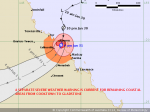
check out the new remote control Jockey Wheel SmartBar Canegrowers rearview170 Cobb Grill Skid Row Recovery Gear Caravan Industry Association of Australia
Members Login
Username 
 
Password 
    Remember Me  
Post Info TOPIC: TROPICAL CYCLONE FORECAST TRACK MAP


Guru

Status: Offline
Posts: 4567
Date:
TROPICAL CYCLONE FORECAST TRACK MAP


Tropical Low

Issued at 4:47 am EST Wednesday 29 January 2014. Refer to Tropical Cyclone Advice Number 4. 
 
IDQ65001.png


Attachments
__________________

Retired Airline Pilot and Electrician..

I'm not old, I've just been young a long time....Ken

Since light travels faster than sound, some people appear bright until you hear them speak.


Veteran Member

Status: Offline
Posts: 97
Date:

Looks like just some decent rainfall, hopefully can get through summer/autumn without any destructive cyclones/flooding this year.

__________________

Life's to short not to live it. :-)


Guru

Status: Offline
Posts: 680
Date:

Hope it helps the poor farmers that are in this shocking drought.

__________________

Where there is a will there is a way!!


Guru

Status: Offline
Posts: 4234
Date:

thanksBig Gorilla I was wondering that. Can you tell me where St Lawrence is?


__________________


Guru

Status: Offline
Posts: 4567
Date:

the rocket wrote:

thanksBig Gorilla I was wondering that. Can you tell me where St Lawrence is?


 St Lawrence is a small town in Queensland, located 802 kilometres (498 mi) north of Brisbane and 6 kilometres (3.7 mi) off the Bruce Highway. It is part of the Isaac Regional Council local government area. About halfway between Rockhampton and Mackay...


__________________

Retired Airline Pilot and Electrician..

I'm not old, I've just been young a long time....Ken

Since light travels faster than sound, some people appear bright until you hear them speak.


Guru

Status: Offline
Posts: 6997
Date:

So Rockhampton will miss it... hope they get some rain, been dry up there...

How are you Sheba?

__________________

Cheers,  Gerty. ... at home

"Leaning forward to see whats coming"


Senior Member

Status: Offline
Posts: 184
Date:

On the track forecast it heads for Hughenden which has been in drought for 12+ months. We are about 120 km SSE of Hughenden and on Sat/Sun we had 35mm which is more than they had here for the whole of 2013. Hardly drought breaking stuff but most welcome nonetheless. Having lived on the tropical coast (Cardwell) for 20 years I've seen 1or 3 cyclones but My guess is this one is a bit of a wimp but if the track map is right we should get a bit of rain out of it. Don't tell the TV mobs but we'll all be out in it dancing and yelling. Cheers.

__________________


Guru

Status: Offline
Posts: 4567
Date:

UPDATE 30 Jan. 2014.

TROPICAL CYCLONE FORECAST TRACK MAP

Tropical Low

Issued at 5:07 am EST Thursday 30 January 2014. Refer to Tropical Cyclone Advice Number 12.
 
 BOM.png
 
sh1114.gif


Attachments
__________________

Retired Airline Pilot and Electrician..

I'm not old, I've just been young a long time....Ken

Since light travels faster than sound, some people appear bright until you hear them speak.


Chief one feather

Status: Offline
Posts: 17335
Date:

It doesn't appear too severe Ken, if I read that correctly. I am guessing the number 1 means category 1. Has it been named yet?


Edit.... It seems to have gone a little further south, nearly a direct hit on Townsville, bugga, my daughter and her family live there.


-- Edited by Dougwe on Thursday 30th of January 2014 06:58:50 AM

__________________

Live Life On Your Terms

DOUG  Chief One Feather  (Losing feathers with age)

TUG.......2014 Holden LT Colorado Twin Cab Ute with Canopy

DEN....... 2014 "Chief" Arrow CV  (with some changes)


Guru

Status: Offline
Posts: 4567
Date:

The lower map gives more detail. It appears it will hit land around Ayr on Jan31 at around 11 a.m. Wind speeds forecast at 40 knots with gusts to 50 knots. (75 to 90 KPH) It's not a monster but will bring heavy rain and strong winds to coastal areas from Innisfail to Mackay.  People in the area should batten down the hatches. People with caravans and MHs should head west or south west. The further inland it goes, the better coz the wind strength will be reduced considerably and it will bring much needed rain to the western parts of Qld. It's being referred to as "Cyclone Dylan" but I'm not sure if it has been officially declared a Cyclone.


__________________

Retired Airline Pilot and Electrician..

I'm not old, I've just been young a long time....Ken

Since light travels faster than sound, some people appear bright until you hear them speak.


Senior Member

Status: Offline
Posts: 184
Date:

Hi all. Heading west is good advice. Once you get 250-300km inland the effects of the wind are a lot less, still a fair chance of getting a wet bum though. We have room for 60+ rigs out here at Kooroorinya Nature Reserve which is 350km WSW of Townsville sealed road all the way. Cheers.


__________________


Guru

Status: Offline
Posts: 4567
Date:

This weather system has now been declared a Cat. 1 Cyclone. 

Remarks:

Tropical Cyclone Dylan has formed off the north Queensland coast and is expected to continue moving in a general southwesterly direction and gradually intensifying, before crossing the Queensland coast between Lucinda and Proserpine in the early hours of Friday morning.

The cyclone and a strong ridge of high pressure further south are combining to generate GALES at times along much of the east coast between Cardwell and St Lawrence. Winds are expected to increase further between Lucinda and St Lawrence, particularly about the Central Coast and Whitsundays district, during the remainder of today and extending to adjacent inland areas on Friday morning with DAMAGING WIND GUSTS to 120 kilometres per hour possible.

Heavy rain, which may lead to flash flooding, is expected to develop about coastal and adjacent inland areas of the Herbert and Lower Burdekin and the Central Coast and Whitsundays districts during today.

Coastal residents between Lucinda and St Lawrence, including Townsville are specifically warned of the dangerous storm tide, particularly on the high tide today and on Friday. The sea is likely to rise steadily up to a level well above the normal tide, with damaging waves and flooding of some low-lying areas close to the shoreline. People living in areas likely to be affected by this flooding should take measures to protect their property as much as possible and be prepared to follow instructions regarding evacuation of the area if advised to do so by the authorities.

A storm tide is expected between Cardwell and Lucinda, particularly on the high tide on Thursday and Friday. Large waves may produce minor flooding along the foreshore. People living in areas likely to be affected by this flooding should take measures to protect their property as much as possible and be prepared to help their neighbours.

A separate Severe Weather Warning is current for remaining coastal and island communities from Cooktown to Cardwell and from St Lawrence to Gladstone.

People between Cardwell and Mackay should take precautions and listen to the next advice at 5pm.
- Information is available from your local government
- For cyclone preparedness and safety advice, visit Queensland's Disaster Management Services website (www.disaster.qld.gov.au)
- For emergency assistance call the Queensland State Emergency Service (SES) 


__________________

Retired Airline Pilot and Electrician..

I'm not old, I've just been young a long time....Ken

Since light travels faster than sound, some people appear bright until you hear them speak.


Guru

Status: Offline
Posts: 4567
Date:

sh1114.gif

TROPICAL CYCLONE FORECAST TRACK MAP

Tropical Cyclone Dylan

Issued at 4:58 am EST Friday 31 January 2014. Refer to Tropical Cyclone Advice Number 20.
 
 IDQ65001.png

Remarks:

Tropical Cyclone Dylan made landfall near Hideaway Bay (east of Bowen), at approximately 3:30am (AEST), as a Category 2 cyclone.

It is now moving further inland and weakening.

DAMAGING WIND GUSTS to 120 kilometres per hour are currently occurring in coastal areas between Ayr and Sarina and will extending to adjacent inland areas later this morning.
DESTRUCTIVE WIND GUSTS to 140 kilometres per hour may still occur close to the system centre during the next few hours.
These winds are expected to ease by late morning.

Heavy rain, which may lead to flash flooding, is expected about coastal and adjacent inland areas of the Central Coast and Whitsundays districts.

Coastal residents between Ayr and Sarina are specifically warned of the
dangerous storm tide on this morning's high tide. The sea is likely
to rise steadily up to a level well above the normal tide, with damaging
waves and flooding of some low-lying areas close to the shoreline.
People living in areas likely to be affected by this flooding should take
measures to protect their property as much as possible and be prepared to
follow instructions regarding evacuation of the area if advised to do so
by the authorities.

A separate Severe Weather Warning is current for remaining coastal and island communities from Cooktown to Ayr and from Sarina to Gladstone, extending inland to the northern Central Highlands and eastern parts of the Central West districts during today.

People between Ayr and Sarina should remain inside until the cyclone has passed and listen to the next advice at 8 am.
- For cyclone preparedness and safety advice, visit Queensland's Disaster Management Services website (www.disaster.qld.gov.au)
- For emergency assistance call the Queensland State Emergency Service (SES) on 132 500 (for assistance with storm damage, rising flood water, fallen trees on buildings or roof damage).

Name:  Tropical Cyclone Dylan 


Attachments
__________________

Retired Airline Pilot and Electrician..

I'm not old, I've just been young a long time....Ken

Since light travels faster than sound, some people appear bright until you hear them speak.


Veteran Member

Status: Offline
Posts: 87
Date:

Phew. Dodged a bullet. Dylan came smack bang over my house. I'm 17 kms from Hydeaway Bay. Lost a couple of trees, otherwise ok.


__________________

www.squidoo.com/camping-in-queensland-australia 


Senior Member

Status: Offline
Posts: 184
Date:

Hi Willow and all. Pleased to hear you suffered no damage. Lovely part of the world you are in, in fact we'll be stopping in for a week or two in 3-4 months time. See you around ? Cheers.

__________________
Page 1 of 1  sorted by
 
Quick Reply

Please log in to post quick replies.

Tweet this page Post to Digg Post to Del.icio.us
Purchase Grey Nomad bumper stickers Read our daily column, the Nomad News The Grey Nomad's Guidebook